Intense rainfall events that trigger flooding are occurring more frequently throughout Iowa, and this trend is expected to continue. Communities need to develop more resilient strategies to address increasing flood risks. A starting point is to clarify common misperceptions about rainfall probabilities and understand different types of flooding.
Types of flooding
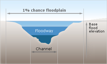
A floodplain is the channel of a river and adjacent land areas that are protected from development. Some communities are required to regulate development in these floodways to ensure there are no increases in upstream flood elevations. These regulations are crucial for community resilience and safety.
Floodplains serve as nature’s storage areas for heavy rains, helping reduce downstream flooding impacts. Every waterbody has a floodplain, from the smallest creek to the largest river.
When rainfall exceeds what urban drainage systems can handle, flooding occurs. There are two main types of flooding related to stormwater management:
Flash floods
Flash floods result from intense, localized storms where substantial rain falls in a short period. These typically affect smaller areas within a watershed and are particularly dangerous because of their suddenness and speed—making them difficult to predict.
Urban areas are increasingly vulnerable to flash flooding due to:
- More frequent intense rainfall events
- Removal of natural vegetation
- Expansion of impervious surface areas
- Drainage systems designed to quickly channel water without adequate storage
Extreme floods
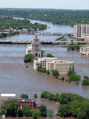
Extreme floods are caused by large-scale weather systems generating prolonged rainfall over wide watershed areas. While still dangerous, these events are generally easier to predict. The Iowa Flood Center is working to help communities with mapping, monitoring, and responding to potential floods.
Since the early 1990s, most of Iowa’s urban communities have required flood control practices like detention and retention basins. However, this “one-size-fits-all” approach may not adequately address flooding caused by urban development, especially in watersheds with agricultural development. More comprehensive, watershed-based approaches are becoming necessary to enhance community resilience.
Changing rainfall patterns
Rainfall events are estimated through recurrence intervals that express the likelihood (as a percentage) that a storm of specific duration and volume will be exceeded in one year. This is known as the Annual Exceedance Probability:
- A “2-year storm” (2.91 inches of rain over 24 hours) has a 50% chance of occurring in any given year
- A “100-year storm” (6.61 inches of rain over 24 hours) has a 1% chance of occurring in any given year
The term “100-year storm” doesn’t mean it occurs only once every century—it means a storm of that magnitude has a 1% chance of happening in any given year.
As rainfall patterns shift, however, these historical probabilities are changing. Events once considered rare are occurring more frequently, requiring communities to update infrastructure design standards, floodplain management regulations, and implement more adaptable stormwater management approaches to enhance resilience to these changing conditions.
Other resources
Additionally, the Iowa Flood Center has developed many tools for communities in Iowa to assess and predict the impacts of flooding. Check out IFC’s helpful tools for more information